|
|
Post by scottwashburn on Oct 8, 2017 13:19:50 GMT
I've finished drawing the maps for Book 3. Here's a sample: 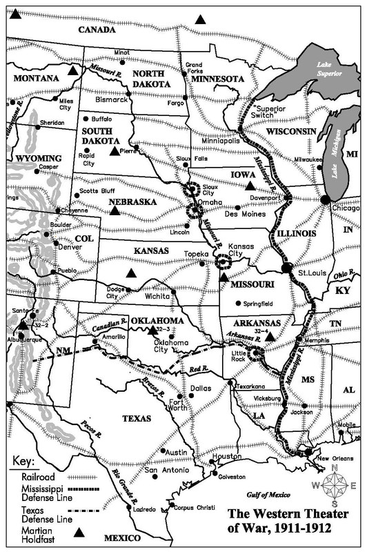 |
|
|
|
Maps!
Oct 8, 2017 22:19:17 GMT
Post by mikedski on Oct 8, 2017 22:19:17 GMT
Do the Martians occupy the territory or do they just range out from their hold fasts? Like their version of Fort Apache?
|
|
|
|
Maps!
Oct 8, 2017 23:35:33 GMT
Post by scottwashburn on Oct 8, 2017 23:35:33 GMT
Just range out from the holdfasts. At least so far  |
|
|
|
Post by hardlec on Oct 9, 2017 9:10:36 GMT
Is it possible that Cape Girardeau, MO still holds out? In 1910 there were still "the bones" of the Civil War defensive positions still there.
Where is "Q's" holdfast?
This is awesomeness!
|
|
|
|
Maps!
Oct 9, 2017 11:38:44 GMT
Post by scottwashburn on Oct 9, 2017 11:38:44 GMT
Cape Giradeau, being right on the Mississippi (west bank,) has probably been raided and damaged at times, but with the river right there and the potential for navy support, the Martians would not linger. The army would doubtlessly have an outpost there if not a permanent garrison. Hardy citizens might hang on, too. Once the main sections of the Mississippi Line were secured, a more substantial garrison might be assigned and fortifications built. The Americans want to hang onto as much territory as they can.
Q's holdfasts are the ones with numbers next to them. 32-2, 32-3, 32-4. 32-1, the original one at Gallup, is off the map.
|
|
|
|
Maps!
Oct 9, 2017 20:19:43 GMT
Post by easye on Oct 9, 2017 20:19:43 GMT
I think Minneapolis is spelled wrong.
My game campaigns take place onear the rail line that connects Minneapolis and Grand Forks in the Minnesota River Valley.
|
|
|
|
Maps!
Oct 9, 2017 21:54:22 GMT
Post by scottwashburn on Oct 9, 2017 21:54:22 GMT
That's the new Martian spelling Thanks! I shall correct it! |
|
|
|
Maps!
Oct 10, 2017 1:47:48 GMT
Post by scarapis on Oct 10, 2017 1:47:48 GMT
Man that map seriously changed by 1914  |
|
|
|
Post by hardlec on Oct 10, 2017 11:57:10 GMT
My developing fan fiction campaign is based in Cape Girardeau. It is a major river port and had a major ferry as well. Bridges across the Mississippi were few and far between in 1911. I lived near the Cape for a couple of years.
I'll definitely want to avoid Q. It looks like he has eyes on Memphis.
|
|
|
|
Maps!
Oct 13, 2017 10:42:22 GMT
Post by riftsinger on Oct 13, 2017 10:42:22 GMT
nice map love the detail helps when reading to refer back when you don't know the areas well
|
|
|
|
Post by gdieckhaus on Oct 13, 2017 20:09:29 GMT
|
|
|
|
Maps!
Oct 24, 2017 21:15:08 GMT
Post by hardlec on Oct 24, 2017 21:15:08 GMT
I have been through a Kansas twister. A Cat. 5 hurricane was a comparative cakewalk.
It's got me wondering if a Tripod could be discombobulated by a strong wind?
|
|
|
|
Maps!
Oct 24, 2017 23:34:32 GMT
Post by boxholder on Oct 24, 2017 23:34:32 GMT
Quite likely to get quite a ride in a tornado.
UNLESS they could find a depression or gully and hunker down in the "loading position." That might reduce the profile to a small enough value to avoid being blown about.
|
|
|
|
Maps!
Oct 25, 2017 5:07:19 GMT
Post by scarapis on Oct 25, 2017 5:07:19 GMT
I have been through a Kansas twister. A Cat. 5 hurricane was a comparative cakewalk. It's got me wondering if a Tripod could be discombobulated by a strong wind? I'm sure the Tripods would be ok, remember Mars has some wind storms that make our strongest storms look like a slight breeze. their lack of atmosphere or such lets storms blow with no resistance whatsoever. |
|
|
|
Post by scottwashburn on Oct 25, 2017 9:49:07 GMT
Do not worry, the Martians learn quite a bit about tornadoes in the next book! |
|